
Laguna Mountain Recreation Area
The Laguna Mountain Recreation Area is located in the Descanso District of the Cleveland National Forest 50 miles east of San Diego. It was designated a National Recreation Area by Presidential proclamation in 1926. Most of the trails are very buff single track with picturesque scenery. The trail system out here is a great place to introduce beginners to "real" trails. Additionally the trail system is great for connecting other trails together for some truly epic rides. The Laguna/Noble route, the Cuyamaca to Noble route and of course the famed Tour De Noble are the three prominent ones.
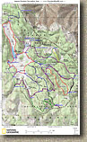
 Click
on the image to the left for a map of the Laguna Mountain Recreation Area. (Map is formatted for printing on 8.5" by 14" paper)
Click
on the image to the left for a map of the Laguna Mountain Recreation Area. (Map is formatted for printing on 8.5" by 14" paper)
Data Files: TOPO! GPX GDB Google Earth KML
Note: The data files above contain contain each trail spur as an individual track to allow to piece together your own route.
Hazards: This place is hot in the summer. Watch out for other trail users as this is a popular area. During the Fall and Winter months you can get yourself caught in some winter storms which can sometimes include snow.
Directions: There are a many ways to check out the Laguna Mountain Recreation Area. You can start from the Noble Canyon/Penny Pines trailhead at the far north end of the area, at the Big Laguna Campground, the Red Roost Volunteer Center or and the Meadows Information Kiosk at the south end of the area. Starting from the south end of the area is more of an intermediate ride, while starting from the north end is better for novice riders.
To start from the South End of the Recreation Area: From San Diego, take I-8 east 45 miles to the off ramp for Sunrise Highway. Take Sunrise Sunrise Highway and go up the mountain. About 1/2 mile after entering the Laguna Recreation Area you will see the Meadows Information Kiosk off the right side of the road just past mile marker 19. Park somewhere along the side of the road here. A National Forest Adventure Pass is required
To start from North End of the Recreation Area: Follow the same directions above but continue on Sunrise Highway past the Kiosk for about 6 miles to the Penny Pines/Noble Canyon Parking area about a 1/4th a mile beyond mile marker 27.5.
The Redtail Roost (Laguna Mountain Volunteer Center) is about 3.5 miles past the Meadows Information Center on the west side of the road.
The General Store is a mile past the Redtail Roost and you can pick snacks, an adventure pass, and a descent map that includes other stuff in the area like, Noble Canyon, Indian Creek, the PCT and all the campgrounds. The Laguna Camground is 2.5 miles past the General Store.
Ride Report:
Note: This report is cicra 1999/2000 and describes a route that included the Wooded Hills area which is now marked as "No-Bikes" near the campground but marked as open to bikes at it southern end off of Old-County Road. I have left this report as is for historical reasons.

 This ride was done as part of a combination Laguna and Noble Canyon combination
ride which I describe at the bottom. We rode the entire Laguna route
described here, but instead of coming back we connected with Noble Canyon.
Here we are parked on the side of Sunrise Highway by the first wildlife kiosk on the right.
This ride was done as part of a combination Laguna and Noble Canyon combination
ride which I describe at the bottom. We rode the entire Laguna route
described here, but instead of coming back we connected with Noble Canyon.
Here we are parked on the side of Sunrise Highway by the first wildlife kiosk on the right.

 Just
up the road from the wildlife kiosk there is an old paved road off to the
left. (I think there is a gate with a "bike-around" across
it). Head down this way. The road quickly crumbles away and
below long it bends to the right and follows along Los Rasalles Ravine as you
start a very gentle climb. (My route description through this area is a
little shaky, but the route on the map will get you there) After climbing
for a while you will see a well used single track off to your right. Take
this single track. It is smooth but your climbing efforts will intensify a
little. This single track works its way up and around a hill.
It will
Just
up the road from the wildlife kiosk there is an old paved road off to the
left. (I think there is a gate with a "bike-around" across
it). Head down this way. The road quickly crumbles away and
below long it bends to the right and follows along Los Rasalles Ravine as you
start a very gentle climb. (My route description through this area is a
little shaky, but the route on the map will get you there) After climbing
for a while you will see a well used single track off to your right. Take
this single track. It is smooth but your climbing efforts will intensify a
little. This single track works its way up and around a hill.
It will 
 eventually
join up with a double track at the apex of a turn (on the double track)
You will take double track straight/left (uphill). (This double track is
show as "Old County Road" on the map.) This double track quickly
narrows as you work your way towards Los Gatos Ravine. Near here you the
trail will cut through a meadow that offers some stunning views of the
surrounding mountains and forests.
eventually
join up with a double track at the apex of a turn (on the double track)
You will take double track straight/left (uphill). (This double track is
show as "Old County Road" on the map.) This double track quickly
narrows as you work your way towards Los Gatos Ravine. Near here you the
trail will cut through a meadow that offers some stunning views of the
surrounding mountains and forests.


After some cruising through the trees for a while you come out in the Laguna Meadow proper.

The Laguna Meadow
The trail is well defined as it skirts along the meadow we did a little side loop (Lightning Ridge) that shortly brought us back to the main meadow were we continued along the Big Laguna Trail.

Another meadow pan shot.


Eventually the Big Laguna trail leaves the meadow and weaves through the pine trees. After going through a horse gate you join up with the Noble Canyon trail. About 75 yards up the trail to your right is Sunrise Highway and the upper trailhead for Noble Canyon. You will have around 12 miles of riding under your belt at this point.
 |
Q: Anybody know what critter is doing this ? |
 |
| A: I finally got an answer to question from a website reader in the know. Woodpeckers make these holes an then jam the acorns in the hole as a way to store them up for the winter. | ||

The Penny Pines/Upper Noble Canyon trailhead parking area. There is a water faucet
beside the trail just below the trail head. Make sure your water is topped
off before you head back.

If you cross sunrise highway there is a quick 200 yard hike from the upper trailhead over to the Pacific Crest Trail which offers a stunning view of the Anza-Borrego Desert below.
Laguna to Noble Combination Ride
Read my Noble Canyon review then you can use the map and profile below. It is technically difficult with narrow single track, gnarly rocks and tight switchbacks. Combining these two areas gets you some nice cross country riding coupled with the demanding thrill of a technical downhill ride. You will need two cars to do this ride as it is a point-to-point. Simply do the Laguna Ride starting from either the Meadows Information Center or from Redtail Roost. Instead of doing a loop continue onto Noble Canyon and down into Pine Valley where your other car waits.

![]()
Here is the map and elevation profile for the Laguna to Noble Canyon version of this ride.
Download the TOPO! file here
Hazards: This place is hot in the summer. Technical single track with some very nasty rocks all over the place.
Directions: From San Diego, take I-8 east to the off ramp for Pine Valley. Exit the highway and turn left. Travel north for .3 miles to Old Highway 80. Turn right and travel about .3 miles and you will see the General Store on your left. Park the shuttle car in the parking lot. With the other vehicle, continue on east on Old Highway 80 to the intersection on Sunrise Highway. Turn left onto Surise Highway and go up the mountain. About 1/2 mile after entering the Laguna Recreation Area you will see a Wildlife Information Kiosk off the right side of the road. Park somewhere along the side of the road here.
2005 Update
The Laguna Mountains have been exceptionally pretty this year with all of the winter rains that we had. Here are a few shots taken in July of 2005.


Big Laguna Lake (It was dry last year)
2008 Update

 Great News! Most of the "non-system" trails in the area that have been in use for many years have been fully legitimized and/or offically signed. The San Diego Mountain Bike Association and the Descansco District of the USFS have a long-standing good relationship that is working to the benefit of all the trail users in this area. I have updated the map at the top of the page to include those trails. You will find that following the naming convention of the trail systems to be somewhat confusing at first. Nearly every trail is called the Big Laguna Trail. More percisely they are labeled Big Laguna Trail Spurs. This is not always obvious so looking on the other side of the trail signs you see will often give you some additional information like the name of the spur.
A Big Big Laguna Mountain Loop
Most people will get a bunch of mileage in this area by connecting this area with Noble Canyon and/or the Cuyamacas. Once you get to know the area there are some stupidly huge rides you can put together. You don't have to leave the area to get in some sizable riding. The looped described here is solely within the Laguna Mountain Recreation Area. It is around 18 miles in length with around 1,500-2000 feet of climbing. Use my map above as I refer to wapoints on that map. For those of you who want to take this description and upload the track right to your GPS here is the Mapsource File, and a GPX file for the route. This is just one route of numerous combinations you can do in this area. NOTE: The pictures interspersed below are from a weekend camping trip in September 2007 with my two boys. We mostly stuck to the main Big Laguna Trail (BLT) down along the perimeter of the meadow. |
|
|
|
|
|
   |
|
|
There are two ways to get to Redtail Roost from here. The first option below gets you close to the General Store you need supplies or water. The second option is a little tougher but it much more interesting.
|
  Just before you came out into the parking lot, you should have noticed a fork going off back into the woods. You will be going on this trail. If you are in the parking looking (BLT-22) at the signed Redtail Roost trail you will see that the trail immediately forks to the left and right. Take the left fork and enjoy a bit of ridge top riding before the trail turns in the downward direction for the better part of it's 1.7 mile length. I really think this is a special section of trail and I am pretty sure you will think it is worth the extra effort required to get to the top of it.
 |
|
|
  Following along the edge in meadow in about 3/10ths of a mile you will soon see Big Laguna Lake directly in front of you (BLT-2). You should recognize where you are at as you came down the other side of the meadow and lake earlier in the ride. While there are a couple smaller trails they work there way over to the lake and across the earthen dam, take the main trail that bends to the right and up the east side of the meadow. Following along the edge in meadow in about 3/10ths of a mile you will soon see Big Laguna Lake directly in front of you (BLT-2). You should recognize where you are at as you came down the other side of the meadow and lake earlier in the ride. While there are a couple smaller trails they work there way over to the lake and across the earthen dam, take the main trail that bends to the right and up the east side of the meadow. |
 
After about a mile you will pass by where the El Prado Spur joins the main trail. A little over half a mile further and you reach the top of the meadow (BLT-1) where you can retrace your route from earlier today back to the Penny Pines/Noble Canyon trailhead. |