  Sometimes referred to as the "SMaRT", this trail system offers
quite a bit of variety along with enough options to get in just about as many
miles as you would like. The Santa Margarita River Trail was mainly
developed by the equestrian community of Fallbrook working with the Fallbrook
Land Conservancy. I first started riding here in 2000 and kept the area on
the down low as I had not fully explored the entire area. In 2002 a
fire in the Fallbrook area damaged the western end of the area and turned the sandy
soil along the trail into one gigantic sandpit, destroying the "feel" of that
area. I stopped riding there and only checked in on it's recovery about once a
year until 2005 when the western area was suitable to ride again.
This is when I dedicated some time to figuring out the majority of the network
and I am quite impressed with what is available considering I did not originally
rate this trail system very highly. Sometimes referred to as the "SMaRT", this trail system offers
quite a bit of variety along with enough options to get in just about as many
miles as you would like. The Santa Margarita River Trail was mainly
developed by the equestrian community of Fallbrook working with the Fallbrook
Land Conservancy. I first started riding here in 2000 and kept the area on
the down low as I had not fully explored the entire area. In 2002 a
fire in the Fallbrook area damaged the western end of the area and turned the sandy
soil along the trail into one gigantic sandpit, destroying the "feel" of that
area. I stopped riding there and only checked in on it's recovery about once a
year until 2005 when the western area was suitable to ride again.
This is when I dedicated some time to figuring out the majority of the network
and I am quite impressed with what is available considering I did not originally
rate this trail system very highly. |
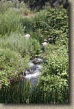
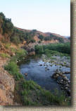
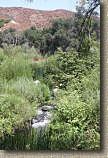
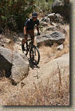
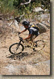
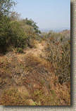
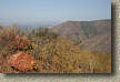
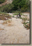
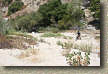
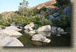
  Some of the singletrack that you find along this trail is quite
different that most of the trails in San Diego County. Particularly some
trails in the Oak forests alongside creeks. Sure there are other trails
like this in the county but this trail has something different about that must
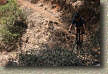
be experienced. Be fore warned, if you loath riding on loose stuff
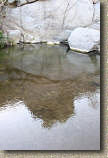
you might not have fun here. There are sporadic sand pits that must
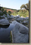
be negotiated, particularly down close to the river bed, as the raging waters of the extremely wet winter of 2004/5 caused the river to
reshape quite a
few sections of the low lying trails and dump a lot of sand over the trail.
In some of these spots you will have to hike up to 30 yards at a
pop. The sandy trails are best packed in the winter and are at their
loosest near the end of summer. This area is also very popular with the equestrian community so
the trails have that slightly pulverized feel that horse trails tend to get in
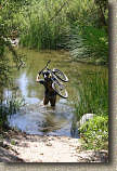
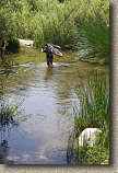
some places particularly on the steep pitches. Also to do some of the bigger and cooler loops
you have to be willing to get wet. I'm not talking just your feet, but
wading across the river that is usually mid-quad to crotch deep.
Okay, even with all of those items this area is worth getting to know. Some of the singletrack that you find along this trail is quite
different that most of the trails in San Diego County. Particularly some
trails in the Oak forests alongside creeks. Sure there are other trails
like this in the county but this trail has something different about that must
be experienced. Be fore warned, if you loath riding on loose stuff
you might not have fun here. There are sporadic sand pits that must
be negotiated, particularly down close to the river bed, as the raging waters of the extremely wet winter of 2004/5 caused the river to
reshape quite a
few sections of the low lying trails and dump a lot of sand over the trail.
In some of these spots you will have to hike up to 30 yards at a
pop. The sandy trails are best packed in the winter and are at their
loosest near the end of summer. This area is also very popular with the equestrian community so
the trails have that slightly pulverized feel that horse trails tend to get in
some places particularly on the steep pitches. Also to do some of the bigger and cooler loops
you have to be willing to get wet. I'm not talking just your feet, but
wading across the river that is usually mid-quad to crotch deep.
Okay, even with all of those items this area is worth getting to know. |
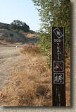
Directions:
|
From Inland areas of San Diego County: Take
I-15 North. A couple of mile after passing HWY 76, take the Mission Road exit.
Turn left at the exit towards Fallbrook. Take Mission Road about 5 miles
and make a right on Pico. (There is a sign that says "To De Luz Road". Pico
turns into De Luz Road. Two Miles after you turned on Pico, you will come
to a fork in the road. Go right at the fork onto Sandria Creel Rd and
travel another two miles to the trailhead parking lot on the right. If you
cross a bridge you have gone to far. |
|
Secondary Trailhead at Willow Glen: From Inland
areas of San Diego County: Take
I-15 North. A couple of mile after passing HWY 76, take the Mission Road exit.
Turn left at the exit towards Fallbrook. Take Mission Road about 2 miles
and make a right on Willow Glen. Take Willow Glen 3.2 miles down into the
Santa Margarita Basin until it ends at the junction of the Stage Coach lane.
Park in the large dirt area on the right hand side of the road. |
General etiquette reminder: When dealing with
horses, cyclists should yield to horses. You should stop and move to the
side or off the trail with ample distance so the the horse has plenty of time to figure you out.
Make conversation with the rider as this will help to ease any anxiety the
animal may have about your presence. Horses on the trail may act
unexpectedly if spooked or frightened and the last thing you want is to get
kicked by a frightened horse. While horse owners are responsible to
make sure their horse has the temperament and training for riding on public
trails, this trail system is not particularly busy and is predominately known as
"horse country". This makes your chances of encountering a rider with a
"green" horse much higher than what you may find on many of the
county's other
multi-use trails. You are an ambassador for the cycling community
so leave our equestrian trail users with a positive experience. |
 |
Trail Map
of the area (No elevation profile as there are too many options) The map is
sized to be printed on 8.5" by 14" sized paper. Download the TOPO! file. |
 |
| Ride Notes: |
| There are many options for rides here that can be expanded into
well over 20 miles. This is one of my more complicated and lengthy trail
descriptions. This ride will require the use of some navigation skills on
your first time out, particularly if you try some of the expanded loops. I
recommend you stop at key intersections and gather as many visual cues as you
can. Also look behind you after key junctions as things can look quite
different coming from the opposite direction. This first description is
what I call the base route that involves no river crossings which makes it good
when it is cold out. It is also used as the foundation from which to
add additional trail loops. |
| |
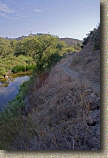
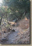
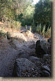
BASE ROUTE:
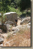
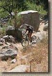
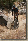
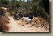
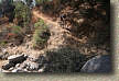
  From the trailhead proceed on the trail east. It is
quite sandy at the start but it does get better. At .25 miles you will
come to a rock garden/cliff side that will have nearly all riders dismounting.
New lines have developed over the last several years but you can clearly see
that the high lines are the older, much more difficult lines. After you
scramble through this section for 30-40 yards the trail becomes smooth again and
the trail is now about 20 feet or so above the river right next to a cliff down
to the riverbed. This used to be a gradual slope down to the rivers edge
but the power of mother nature's raging water during our 2004/5 winter rains
radically reshaped this area of the river. From the trailhead proceed on the trail east. It is
quite sandy at the start but it does get better. At .25 miles you will
come to a rock garden/cliff side that will have nearly all riders dismounting.
New lines have developed over the last several years but you can clearly see
that the high lines are the older, much more difficult lines. After you
scramble through this section for 30-40 yards the trail becomes smooth again and
the trail is now about 20 feet or so above the river right next to a cliff down
to the riverbed. This used to be a gradual slope down to the rivers edge
but the power of mother nature's raging water during our 2004/5 winter rains
radically reshaped this area of the river. |
  Continuing along the trail you will see an off-shoot trail at
around .85 miles going off to your right. There are quite a few of these
along this trail and most of them climb up the finger canyons to the end of
streets. This particularly one climbs for about 3/4th of a mile before
coming out at the end of and someone's home. Feel free to explore them as
you can always retrace your steps back to where you split off from. Continuing along the trail you will see an off-shoot trail at
around .85 miles going off to your right. There are quite a few of these
along this trail and most of them climb up the finger canyons to the end of
streets. This particularly one climbs for about 3/4th of a mile before
coming out at the end of and someone's home. Feel free to explore them as
you can always retrace your steps back to where you split off from. |
  At 1.35 miles you will come to split in the trail. Take
the split to the right and go uphill for maybe 1/10th of a mile where the trail
joins an old fire road where you will turn right and continue uphill.
Don't worry if you miss this split as the lower trail will seemingly dead end
at the rivers edge in about 2/10th of a mile. If this happens just turn
around and look for the fireroad off to your left and take it uphill where you
will soon pass by the top of the trail/fireroad junction you should have taken
originally. This fire road is steep but short and at 1.5 miles you
will turn left and downhill by an oak tree in the middle of an open area.
The downhill is short as well and you will soon be back to following along the
river. At 1.35 miles you will come to split in the trail. Take
the split to the right and go uphill for maybe 1/10th of a mile where the trail
joins an old fire road where you will turn right and continue uphill.
Don't worry if you miss this split as the lower trail will seemingly dead end
at the rivers edge in about 2/10th of a mile. If this happens just turn
around and look for the fireroad off to your left and take it uphill where you
will soon pass by the top of the trail/fireroad junction you should have taken
originally. This fire road is steep but short and at 1.5 miles you
will turn left and downhill by an oak tree in the middle of an open area.
The downhill is short as well and you will soon be back to following along the
river. |
     |
  At 1.7 miles the trail comes to a very distinct T-junction.
If you go to the right you will reach The 500' trail. For now turn left
and continue along the SMaRT. You will do some gradual climbing as
the trail gets firmer and rockier for a bit before it descends again back
towards the river bed. At 2.3 miles you will come to another prominent
offshoot trail coming in from your right and uphill. This is a connector
to The 500' Trail, but continue downhill along the SMaRT where you will soon be
back under Oak trees. You actually turn away from the river now and you
will soon, at around 2.5 miles, come to the junction of the Rainbow Creek trail.
If you go to your left you will cross Rainbow creek and continue along the SMaRT.
If you go to the right you will follow the Rainbow Creek trail. For
this route go right on the Rainbow Creek trail. This is one of the
prettiest wooded trails in North County with lots of greenery and trees
alongside a creek. It is quite short but very enjoyable. After
only 1/4th of a mile, at the top of the steep rise, you will come to the eastern
end of The 500' Trail on your right. Remember this spot as you will be
come back this way and take this trail later in the ride. For now continue
on straight and in about a 1/3rd of a mile you will come to a creek crossing.
Cross the creek and you will promptly come out on the paved Willow Glen road.
Your mileage should be around 3.1 miles at this point. At 1.7 miles the trail comes to a very distinct T-junction.
If you go to the right you will reach The 500' trail. For now turn left
and continue along the SMaRT. You will do some gradual climbing as
the trail gets firmer and rockier for a bit before it descends again back
towards the river bed. At 2.3 miles you will come to another prominent
offshoot trail coming in from your right and uphill. This is a connector
to The 500' Trail, but continue downhill along the SMaRT where you will soon be
back under Oak trees. You actually turn away from the river now and you
will soon, at around 2.5 miles, come to the junction of the Rainbow Creek trail.
If you go to your left you will cross Rainbow creek and continue along the SMaRT.
If you go to the right you will follow the Rainbow Creek trail. For
this route go right on the Rainbow Creek trail. This is one of the
prettiest wooded trails in North County with lots of greenery and trees
alongside a creek. It is quite short but very enjoyable. After
only 1/4th of a mile, at the top of the steep rise, you will come to the eastern
end of The 500' Trail on your right. Remember this spot as you will be
come back this way and take this trail later in the ride. For now continue
on straight and in about a 1/3rd of a mile you will come to a creek crossing.
Cross the creek and you will promptly come out on the paved Willow Glen road.
Your mileage should be around 3.1 miles at this point. |
| |
  Turn
right and take Willow Glen Road for 1/2 mile until you come
to a really sharp right-hand turn at the bottom of a steep hill. You
will see a fence in the outside of the turn. Take the trail on the right-hand side
of the fence. You are pretty much done with dealing with loose sandy stuff
now as this trail quickly becomes rocky as you climb about three hundred feet
over the next 1.25 miles. There is one creek crossing about half way along
this trail where you may have to do a bit of looking to find just the right spot to
cross if you want to keep your feet dry. After crossing the creek
you will continue climbing and before long you will come out in a bend of a dirt
road. This is an important spot because you have several options to expand
your riding in this area. I will refer to this spot as the Rainbow Creek
Turnaround in the rest to the descriptions. Turn
right and take Willow Glen Road for 1/2 mile until you come
to a really sharp right-hand turn at the bottom of a steep hill. You
will see a fence in the outside of the turn. Take the trail on the right-hand side
of the fence. You are pretty much done with dealing with loose sandy stuff
now as this trail quickly becomes rocky as you climb about three hundred feet
over the next 1.25 miles. There is one creek crossing about half way along
this trail where you may have to do a bit of looking to find just the right spot to
cross if you want to keep your feet dry. After crossing the creek
you will continue climbing and before long you will come out in a bend of a dirt
road. This is an important spot because you have several options to expand
your riding in this area. I will refer to this spot as the Rainbow Creek
Turnaround in the rest to the descriptions. |
| |
 For this basic route, turn around here and enjoy the mostly
downhill route back to Willow Glen Road, and continue back the way you came
getting back on the Rainbow Creek trail where you initially came out on the
road. Once back on the Rainbow Creek trail take it back to the
junction of The 500' Trail. This time turn left on to The 500'
Trail. For this basic route, turn around here and enjoy the mostly
downhill route back to Willow Glen Road, and continue back the way you came
getting back on the Rainbow Creek trail where you initially came out on the
road. Once back on the Rainbow Creek trail take it back to the
junction of The 500' Trail. This time turn left on to The 500'
Trail. |
| |
  The 500' Trail is quite smooth and for the most part flat as it
follows the contours of the finger canyons for about 1.75 miles where it comes
out into a wide open dirt area. The trail is not so easily followed
so as you come out into this area, look to your 2 o'clock and travel downhill
until you pick up the trail on the downhill and far side of the open dirt area.
From here pickup the downhill singletrack that will quickly take you back to the
T-junction described earlier. Hang a left and you will drop back onto the SMaRT that you were on earlier in the ride. Retrace your route back
to the trailhead. The 500' Trail is quite smooth and for the most part flat as it
follows the contours of the finger canyons for about 1.75 miles where it comes
out into a wide open dirt area. The trail is not so easily followed
so as you come out into this area, look to your 2 o'clock and travel downhill
until you pick up the trail on the downhill and far side of the open dirt area.
From here pickup the downhill singletrack that will quickly take you back to the
T-junction described earlier. Hang a left and you will drop back onto the SMaRT that you were on earlier in the ride. Retrace your route back
to the trailhead. |
BASE ROUTE ADD-ONS
The base route is rather short, but these options can make for
some great riding out in this area.
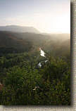
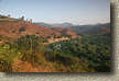
Red Mountain
 From
the Rainbow Creek Turnaround , turn right on the dirt road and follow the road
first downhill and then up a sickening steep climb up to the top of Red
Mountain. There are a couple of dirt intersection here and there but just
keep turning towards the mountaintop and you will get to the top. Your
total mileage out and back from the turnaround will be 3.4 miles, but you will
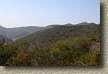
climb 800' in just a 1.3 miles. The views from the top of Red Mountain are quite
nice and if you are feeling adventurous there is a singletrack heading off the
mountain to the south. From what I have been told it will drop you into
Fallbrook where there are some social trails and streets that will allow you to
work your way back to the mail trailhead. From
the Rainbow Creek Turnaround , turn right on the dirt road and follow the road
first downhill and then up a sickening steep climb up to the top of Red
Mountain. There are a couple of dirt intersection here and there but just
keep turning towards the mountaintop and you will get to the top. Your
total mileage out and back from the turnaround will be 3.4 miles, but you will
climb 800' in just a 1.3 miles. The views from the top of Red Mountain are quite
nice and if you are feeling adventurous there is a singletrack heading off the
mountain to the south. From what I have been told it will drop you into
Fallbrook where there are some social trails and streets that will allow you to
work your way back to the mail trailhead. |
| |
The Hills Loop
  From the Rainbow Creek Turnaround, turn left on the
dirt road. After 1/10th of mile you come to a T-junction. Turn left
and follow the fireroad as it turns uphill. At .4 miles there is a split
in the fireroad, go right. For a visual reference point, some where along
through here you will see a house at the top of the canyon in front of you..
You will eventually end up going by that house. At .7 miles
you will see a fire road merging in from your left, continue straight. At
1.0 miles you will come out by the house and a dirt road. Look for a fire
road heading off to the left and take it where you will gradually climb.
As you near the top of this climb, you will see a ridge line bending around from
your right toward about your one o'clock where the ridgeline ends in a point.
Just to the right of that point is a slightly larger hill. You will be following
the fire road around to the point over the top of that slightly larger hill.
Work your way around to the point and as descend from the slightly larger hill
look for a fireroad that merges in from your right and make a note of it as you
continue on straight out to the point. Take in the nice views of this
point and when you are done, head back the way you came and take that fireroad
that you saw merge in earlier. You are going to shed off a good bit of
elevation now as you descend this battered fireroad that has become quite
technical with rocks and ruts. There are only a couple of turnoffs
on this route but just remember that when in doubt go downhill and you will be
on the right route. The final stretch of this will take you by
a house on your right before dumping you out on a dirt road (Stage Coach Lane).
You should have traveled 2.8 miles from the Rainbow Creek Turnaround spot. From the Rainbow Creek Turnaround, turn left on the
dirt road. After 1/10th of mile you come to a T-junction. Turn left
and follow the fireroad as it turns uphill. At .4 miles there is a split
in the fireroad, go right. For a visual reference point, some where along
through here you will see a house at the top of the canyon in front of you..
You will eventually end up going by that house. At .7 miles
you will see a fire road merging in from your left, continue straight. At
1.0 miles you will come out by the house and a dirt road. Look for a fire
road heading off to the left and take it where you will gradually climb.
As you near the top of this climb, you will see a ridge line bending around from
your right toward about your one o'clock where the ridgeline ends in a point.
Just to the right of that point is a slightly larger hill. You will be following
the fire road around to the point over the top of that slightly larger hill.
Work your way around to the point and as descend from the slightly larger hill
look for a fireroad that merges in from your right and make a note of it as you
continue on straight out to the point. Take in the nice views of this
point and when you are done, head back the way you came and take that fireroad
that you saw merge in earlier. You are going to shed off a good bit of
elevation now as you descend this battered fireroad that has become quite
technical with rocks and ruts. There are only a couple of turnoffs
on this route but just remember that when in doubt go downhill and you will be
on the right route. The final stretch of this will take you by
a house on your right before dumping you out on a dirt road (Stage Coach Lane).
You should have traveled 2.8 miles from the Rainbow Creek Turnaround spot. |
| |
|
  Turn right on Stage Coach Lane and travel
1/4th of a mile. Look for a house with a brick wall surrounding the yard
on your left hand side (It is the only house on the left hand side) .
Just after you pass the house look for a single track off to your left, right by
a telephone pole. Take
it. This trail will drop you down into the river bed where it will
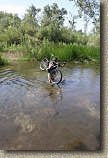
turn into a sand slog. Wade across the narrow river (It is more like a
creek to me, but the water will most likely be quad deep). After you get
on the other side and up the bank you will come out onto a large sand area.
Slog straight across the sand and slightly to your left for about 30 yards
and then turn even more to your left slog through the sand until the trail gets
out of the sand on higher ground. You should not have slogged no more than
80
yards or so total. Turn right on Stage Coach Lane and travel
1/4th of a mile. Look for a house with a brick wall surrounding the yard
on your left hand side (It is the only house on the left hand side) .
Just after you pass the house look for a single track off to your left, right by
a telephone pole. Take
it. This trail will drop you down into the river bed where it will
turn into a sand slog. Wade across the narrow river (It is more like a
creek to me, but the water will most likely be quad deep). After you get
on the other side and up the bank you will come out onto a large sand area.
Slog straight across the sand and slightly to your left for about 30 yards
and then turn even more to your left slog through the sand until the trail gets
out of the sand on higher ground. You should not have slogged no more than
80
yards or so total. |
  Once back up on the trail, enjoy some nice single track both
under the trees as well as out in an open field for about 1.2 miles until you
come to a four-way trail junction with a trail coming in from a steep hill on
your right. You will see a waterline pipe sign on the trail coming down
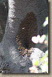
from the hill. If you walk up towards that sign and look at the oak
tree about 30 feet to your left you will see an active bee-hive made out of a
hollow in the tree. Remember this intersection, which I call Bee-Hive
junction, as it is referenced in another loop option. Once back up on the trail, enjoy some nice single track both
under the trees as well as out in an open field for about 1.2 miles until you
come to a four-way trail junction with a trail coming in from a steep hill on
your right. You will see a waterline pipe sign on the trail coming down
from the hill. If you walk up towards that sign and look at the oak
tree about 30 feet to your left you will see an active bee-hive made out of a
hollow in the tree. Remember this intersection, which I call Bee-Hive
junction, as it is referenced in another loop option. |
  At this junction, turn left and downhill to cross the river and
pickup the trail on the other side. Follow the trail for half a mile until
you come to a T-junction were you can see a fence and gate off to your left.
That is the corner of Willow Glen road and Stage Coach Lane. This is
also a place you can park for riding the eastern ends trails. Anyway, turn
right and follow the doubletrack for about a 1/4 of a mile to Rainbow Creek and
cross the creek. You are now at the junction of the SMaRT and the Rainbow
Creek Trail which your were at on your way out if followed the Basic Route
description. If you would like to take the SMaRT back to the trailhead turn
right. If you would like to take the 500' trail back, then turn left.
From here see the basic route description to get back to the trailhead. At this junction, turn left and downhill to cross the river and
pickup the trail on the other side. Follow the trail for half a mile until
you come to a T-junction were you can see a fence and gate off to your left.
That is the corner of Willow Glen road and Stage Coach Lane. This is
also a place you can park for riding the eastern ends trails. Anyway, turn
right and follow the doubletrack for about a 1/4 of a mile to Rainbow Creek and
cross the creek. You are now at the junction of the SMaRT and the Rainbow
Creek Trail which your were at on your way out if followed the Basic Route
description. If you would like to take the SMaRT back to the trailhead turn
right. If you would like to take the 500' trail back, then turn left.
From here see the basic route description to get back to the trailhead. |
| |
The North Side Trail
|
Followed the Basic Route and then took the Hill Loop and are at
the Bee-Hive Junction. |
|
You parked parked at the corner of Willow Glen and Stage Coach
Lane and followed the SMaRT backwards from the Hill Loop description to the
Bee-Hive junction. |
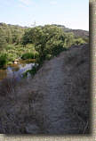  From the Bee-Hive junction, facing west (downstream direction of
the river) proceed straight along the singletrack that follows the path of the
river about 40 feet about the riverbed. This trail is quite nice and
is better experienced than described. At .75 miles you will come to
the junction of an off-shoot trail to your right. It goes up to the end of
a country road, continue straight. At 1.0 miles you will come to a fork in
the trail - Take it - (I know a Yogism) as both trails regroup at the bottom of
the hill you are on. At 1.5 miles you drop down close by the river where
the trail gets sandy. It is quite pretty here but as you continue along
for the next quarter of a mile you will see at least one trail that goes off to
the left that is flat or heading slightly downhill. Don't take any of
these trails. Instead, take any forks to the right where the trail will
gain some ground and generally be firmer riding. You get to do some some
intensive climbing along the single track as it gains about 150 feet in the next
quarter of a mile. As you peak out of the climb you will see a dead-end
road ahead. Look for the trail within 30 yards of "peaking" off to left
and downhill. When you see a steep trail with ruts in it, that is
your way. Go left and downhill. You should be about 2 miles
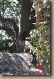
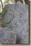
from Bee Hive junction at this point. The next mile is a really
great section. Look for the "Modern" Pictographs as well as Gene Chase
Memorial dedication rock. From the Bee-Hive junction, facing west (downstream direction of
the river) proceed straight along the singletrack that follows the path of the
river about 40 feet about the riverbed. This trail is quite nice and
is better experienced than described. At .75 miles you will come to
the junction of an off-shoot trail to your right. It goes up to the end of
a country road, continue straight. At 1.0 miles you will come to a fork in
the trail - Take it - (I know a Yogism) as both trails regroup at the bottom of
the hill you are on. At 1.5 miles you drop down close by the river where
the trail gets sandy. It is quite pretty here but as you continue along
for the next quarter of a mile you will see at least one trail that goes off to
the left that is flat or heading slightly downhill. Don't take any of
these trails. Instead, take any forks to the right where the trail will
gain some ground and generally be firmer riding. You get to do some some
intensive climbing along the single track as it gains about 150 feet in the next
quarter of a mile. As you peak out of the climb you will see a dead-end
road ahead. Look for the trail within 30 yards of "peaking" off to left
and downhill. When you see a steep trail with ruts in it, that is
your way. Go left and downhill. You should be about 2 miles
from Bee Hive junction at this point. The next mile is a really
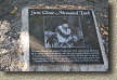
great section. Look for the "Modern" Pictographs as well as Gene Chase
Memorial dedication rock. |
| |
  At 3.0 miles you will come to a sign directing you to a river
crossing and the trailhead leading off to your left. You can go this way
but you will be miserable as it 2/10ths of a mile of super deep sand slogging.
Cool if your on a horse but it blows with a bike. Instead continue
straight and the trail will soon come to a split by a telephone pole.
Bend to the left and follow the singletrack along the edge of a meadow. At
the end of the small meadow the trail will get quite skinny and cross a very
small brook. After crossing the brook you will have to navigate under or
around a fallen oak before popping out on a small paved road. Turn left and follow the road
downhill for .3 miles to the junction of Sandria Creek road. Turn left
here and proceed across the Santa Margarita River Bridge to the trailhead on the
other side of the bridge. (Note: The North Side Trail is
also pretty nice going from West to East) At 3.0 miles you will come to a sign directing you to a river
crossing and the trailhead leading off to your left. You can go this way
but you will be miserable as it 2/10ths of a mile of super deep sand slogging.
Cool if your on a horse but it blows with a bike. Instead continue
straight and the trail will soon come to a split by a telephone pole.
Bend to the left and follow the singletrack along the edge of a meadow. At
the end of the small meadow the trail will get quite skinny and cross a very
small brook. After crossing the brook you will have to navigate under or
around a fallen oak before popping out on a small paved road. Turn left and follow the road
downhill for .3 miles to the junction of Sandria Creek road. Turn left
here and proceed across the Santa Margarita River Bridge to the trailhead on the
other side of the bridge. (Note: The North Side Trail is
also pretty nice going from West to East) |
 |


 Sometimes referred to as the "SMaRT", this trail system offers
quite a bit of variety along with enough options to get in just about as many
miles as you would like. The Santa Margarita River Trail was mainly
developed by the equestrian community of Fallbrook working with the Fallbrook
Land Conservancy. I first started riding here in 2000 and kept the area on
the down low as I had not fully explored the entire area. In 2002 a
fire in the Fallbrook area damaged the western end of the area and turned the sandy
soil along the trail into one gigantic sandpit, destroying the "feel" of that
area. I stopped riding there and only checked in on it's recovery about once a
year until 2005 when the western area was suitable to ride again.
This is when I dedicated some time to figuring out the majority of the network
and I am quite impressed with what is available considering I did not originally
rate this trail system very highly.
Sometimes referred to as the "SMaRT", this trail system offers
quite a bit of variety along with enough options to get in just about as many
miles as you would like. The Santa Margarita River Trail was mainly
developed by the equestrian community of Fallbrook working with the Fallbrook
Land Conservancy. I first started riding here in 2000 and kept the area on
the down low as I had not fully explored the entire area. In 2002 a
fire in the Fallbrook area damaged the western end of the area and turned the sandy
soil along the trail into one gigantic sandpit, destroying the "feel" of that
area. I stopped riding there and only checked in on it's recovery about once a
year until 2005 when the western area was suitable to ride again.
This is when I dedicated some time to figuring out the majority of the network
and I am quite impressed with what is available considering I did not originally
rate this trail system very highly. 

 From the trailhead proceed on the trail east. It is
quite sandy at the start but it does get better. At .25 miles you will
come to a rock garden/cliff side that will have nearly all riders dismounting.
New lines have developed over the last several years but you can clearly see
that the high lines are the older, much more difficult lines. After you
scramble through this section for 30-40 yards the trail becomes smooth again and
the trail is now about 20 feet or so above the river right next to a cliff down
to the riverbed. This used to be a gradual slope down to the rivers edge
but the power of mother nature's raging water during our 2004/5 winter rains
radically reshaped this area of the river.
From the trailhead proceed on the trail east. It is
quite sandy at the start but it does get better. At .25 miles you will
come to a rock garden/cliff side that will have nearly all riders dismounting.
New lines have developed over the last several years but you can clearly see
that the high lines are the older, much more difficult lines. After you
scramble through this section for 30-40 yards the trail becomes smooth again and
the trail is now about 20 feet or so above the river right next to a cliff down
to the riverbed. This used to be a gradual slope down to the rivers edge
but the power of mother nature's raging water during our 2004/5 winter rains
radically reshaped this area of the river.


 From the Rainbow Creek Turnaround, turn left on the
dirt road. After 1/10th of mile you come to a T-junction. Turn left
and follow the fireroad as it turns uphill. At .4 miles there is a split
in the fireroad, go right. For a visual reference point, some where along
through here you will see a house at the top of the canyon in front of you..
You will eventually end up going by that house. At .7 miles
you will see a fire road merging in from your left, continue straight. At
1.0 miles you will come out by the house and a dirt road. Look for a fire
road heading off to the left and take it where you will gradually climb.
As you near the top of this climb, you will see a ridge line bending around from
your right toward about your one o'clock where the ridgeline ends in a point.
Just to the right of that point is a slightly larger hill. You will be following
the fire road around to the point over the top of that slightly larger hill.
Work your way around to the point and as descend from the slightly larger hill
look for a fireroad that merges in from your right and make a note of it as you
continue on straight out to the point. Take in the nice views of this
point and when you are done, head back the way you came and take that fireroad
that you saw merge in earlier. You are going to shed off a good bit of
elevation now as you descend this battered fireroad that has become quite
technical with rocks and ruts. There are only a couple of turnoffs
on this route but just remember that when in doubt go downhill and you will be
on the right route. The final stretch of this will take you by
a house on your right before dumping you out on a dirt road (Stage Coach Lane).
You should have traveled 2.8 miles from the Rainbow Creek Turnaround spot.
From the Rainbow Creek Turnaround, turn left on the
dirt road. After 1/10th of mile you come to a T-junction. Turn left
and follow the fireroad as it turns uphill. At .4 miles there is a split
in the fireroad, go right. For a visual reference point, some where along
through here you will see a house at the top of the canyon in front of you..
You will eventually end up going by that house. At .7 miles
you will see a fire road merging in from your left, continue straight. At
1.0 miles you will come out by the house and a dirt road. Look for a fire
road heading off to the left and take it where you will gradually climb.
As you near the top of this climb, you will see a ridge line bending around from
your right toward about your one o'clock where the ridgeline ends in a point.
Just to the right of that point is a slightly larger hill. You will be following
the fire road around to the point over the top of that slightly larger hill.
Work your way around to the point and as descend from the slightly larger hill
look for a fireroad that merges in from your right and make a note of it as you
continue on straight out to the point. Take in the nice views of this
point and when you are done, head back the way you came and take that fireroad
that you saw merge in earlier. You are going to shed off a good bit of
elevation now as you descend this battered fireroad that has become quite
technical with rocks and ruts. There are only a couple of turnoffs
on this route but just remember that when in doubt go downhill and you will be
on the right route. The final stretch of this will take you by
a house on your right before dumping you out on a dirt road (Stage Coach Lane).
You should have traveled 2.8 miles from the Rainbow Creek Turnaround spot.