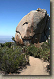
Mount Woodson
If you feel like you and your granny ring have not had much quality time together lately, then head out to Mt Woodson and get reacquainted. The Mount Woodson area is a pretty cool swath of rugged landscape located in the northeast corner of the city of Poway north of San Diego and just south of Ramona. Most of the mountain is covered with large boulders and chaparral with some some sizable trees and groves of oaks as well. You really need to get on the mountain to truly appreciate the word "large" in regards to the boulders. I have had apartments that were smaller than some of these monstrous chunks of the planet. The trails around and on Mount Woodson are often quite steep and technical enough to make this an advanced level ride.

Hazards: There are some spots were an over-the-bars experience could net you some sizable air time to a very rocky landing. The place can be absolutely blazing hot during the summer. This is an extremely popular place with hikers so please remember to use proper trail etiquette. I also highly recommend you have a bike bell on your bike while on the Mt Woodson trail. Because of the tight corners and often short sight lines, use the kind that will make noise on it's own vice you having to ding it. The weekends see the most hiker traffic so a weekday ride would be best.
Directions: There are four locations you could park to do this ride. It all depends what route you wish to do based on the descriptions below:
|
Lake Poway - From Interstate 15, exit Rancho Bernardo Road, travel east 4 miles to Lake Poway Road, turn left and follow to the park entrance gate. The address is 14644 Lake Poway Road, Poway, California 92064. | |
|
CDF Fire Station - From the San Diego area take Interstate 15, north about 15 miles to the Scripps Poway Parkway exit. Turn right (east) and travel 8.6 miles to highway 67. Turn left (north) onto highway 67 heading into Ramona. You will see Mt Woodson on your left (It is the big rocky mountain with a bunch of antennas on top) as you drive north into Ramona. About half a mile after you crest the saddle north of Mt Woodson, look for Hedy Drive on your right and the California Division of Forestry fire station on the left. Park on the dirt shoulder somewhere near here on either side of the road. The trailhead is located right at the entrance to the fire station. | |
|
Archie Moore Road and Rancho De La Angel - Follow the directions above, but continue on past the CDF Fire Station for maybe half a mile (when the road bends to the right) then turn left onto Archie Moore Road. Rancho De La Angel is about a 1/4th a mile up the road on your right. There is a dirt pull out area on the corner. | |
|
Highway 67 pulloff near callbox 67-170 - From the Sam Diego
area take Interstate 15, north about 15 miles to the Scripps Poway
Parkway exit. Turn right (east) and travel 8.6 miles to highway 67.
Turn left (north) onto highway 67 heading towards Ramona. After
approximately 2 miles you will see a call box on your right. There is a dirt
pull out area just beyond the call box that you will use. |
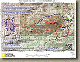
| Topographic Map | 3D Rendering of the map | GPS data files | |
 |
  |
National Geographics TOPO! file |
 |
Ride Description: There are five primary trails in this system and they can be done in different combinations. I am first going to describe each trail then I'll give some route recommendations.
Mt WoodsonTrail |
||||
  The Mt Woodson trail starts on the east side of
Lake Poway (Point E on the map) and travels
uphill at a fairly steep grade on an old dirt road for .9 miles until it
comes to the junction with the Warren Canyon Trail (Point F).
To stay on the Mt Woodson trail you will turn left and go uphill. The Mt Woodson trail starts on the east side of
Lake Poway (Point E on the map) and travels
uphill at a fairly steep grade on an old dirt road for .9 miles until it
comes to the junction with the Warren Canyon Trail (Point F).
To stay on the Mt Woodson trail you will turn left and go uphill. |
||||
  The next .7 miles up to the ridge top is simply freaking
steep. The average grade is 17% and that is without factoring in
the technical spots. I typically refrain from using
absolutes about what riders will do on trails, but I am going to
confidently say that, you will have to stop and carry your bike at least
once on this climb. The next .7 miles up to the ridge top is simply freaking
steep. The average grade is 17% and that is without factoring in
the technical spots. I typically refrain from using
absolutes about what riders will do on trails, but I am going to
confidently say that, you will have to stop and carry your bike at least
once on this climb. |
||||
  The climb does have a few shady areas that make nice
spots for a break. Once you are up on the ridge top the
shade is quite minimal so don't pass up an inviting spot along the
climb. The climb does have a few shady areas that make nice
spots for a break. Once you are up on the ridge top the
shade is quite minimal so don't pass up an inviting spot along the
climb. |
||||
  Once you do get up on the ridge top you will come to a
four-way junction. Off to your left is trail that scrabbles up a slab of
rocks to an impressive viewpoint. Heading off downhill and to the
north is the Fry-Koegle trail. The Mt Woodson trail turns to the
right continues uphill along the ridgeline. Continuing east and uphill
on the Mt Woodson trail, the grade "mellows out" a bit and only gains 700 feet
over the next 1.2 miles to the summit. Be on the lookout for an
unsigned trail heading off to your left about .2 miles from the ridge
top junction. This is the Old Fry-Koegle trail that is a
real slow tech treat going downhill. Once you do get up on the ridge top you will come to a
four-way junction. Off to your left is trail that scrabbles up a slab of
rocks to an impressive viewpoint. Heading off downhill and to the
north is the Fry-Koegle trail. The Mt Woodson trail turns to the
right continues uphill along the ridgeline. Continuing east and uphill
on the Mt Woodson trail, the grade "mellows out" a bit and only gains 700 feet
over the next 1.2 miles to the summit. Be on the lookout for an
unsigned trail heading off to your left about .2 miles from the ridge
top junction. This is the Old Fry-Koegle trail that is a
real slow tech treat going downhill. |
||||

|
||||
   A few more pictures from along tyhe Mount Woodson trail |
||||
Warren Canyon Trail |
||||
  The
Warren Canyon trail packs quite a bit of punch.
The start of the trail at the junction of the Mt Woodson trail to it's
terminus at highway 67 are at the same elevation and separated by 2.3
miles of rugged single track. However, over the course of that 2.3
miles you will climb and descend around 650 feet (both up and down).
None of the climbs or descents or long at all but they are steep.
I spent most of my time either nearly dragging my shorts on the rear
wheel or having my chin inches above my handlebars. I loved this
bit of trail as it sees little traffic compared to the Mt Woodson trail
and it weaved around some really large boulders. The trail had
much more of a backwoods feel to than I expected. The
Warren Canyon trail packs quite a bit of punch.
The start of the trail at the junction of the Mt Woodson trail to it's
terminus at highway 67 are at the same elevation and separated by 2.3
miles of rugged single track. However, over the course of that 2.3
miles you will climb and descend around 650 feet (both up and down).
None of the climbs or descents or long at all but they are steep.
I spent most of my time either nearly dragging my shorts on the rear
wheel or having my chin inches above my handlebars. I loved this
bit of trail as it sees little traffic compared to the Mt Woodson trail
and it weaved around some really large boulders. The trail had
much more of a backwoods feel to than I expected.
Pictures from along the trail |
||||
|
|
||||
  Just before you get to highway 67 the trail will plummet
downhill before turning sharply uphill to go up and meet the
highway. Just as the the trail starts the descend you may notice the
remains of an old trail crossing over the trail. The
City of Poway's trail guide map indicates there are plans
for a trail that seems to follow along this old trail. Just before you get to highway 67 the trail will plummet
downhill before turning sharply uphill to go up and meet the
highway. Just as the the trail starts the descend you may notice the
remains of an old trail crossing over the trail. The
City of Poway's trail guide map indicates there are plans
for a trail that seems to follow along this old trail. |
||||
  Here are a couple of pictures to help with visual
referencing. The picture to the left was taken standing on the edge of
highway 67 looking northwest at Mount Woodson with the Warren Canyon trail
in the foreground. The picture to the right shows the
pull-off area on the east side of the road that can be used as a
trailhead access point. The roadie coming down the hill is almost
right beside where the trail starts. Here are a couple of pictures to help with visual
referencing. The picture to the left was taken standing on the edge of
highway 67 looking northwest at Mount Woodson with the Warren Canyon trail
in the foreground. The picture to the right shows the
pull-off area on the east side of the road that can be used as a
trailhead access point. The roadie coming down the hill is almost
right beside where the trail starts. |
||||
Despite the extra effort and hike-a-bike required in spots, I still consider the Warren Canyon Trail a viable option as it is the path less traveled. |
||||
Mount Woodson Service Road |
||||
  As with nearly all mountains
that have a plethora of antennas on their summit, there is a service
road that will take take to the summit. From the CDF
station at Point H on the map, pickup a trail that heads south
paralleling highway 67 for a short bit before coming out onto a single
lane paved service road that heads up the mountain. This
road gets pretty freaking steep, gaining 1200 feet in 1.8 miles up to
the summit at Point O. This service road is popular with
rock climbers and on a weekend you will most like hear at least few
working on a boulder or two close by the rock. As with nearly all mountains
that have a plethora of antennas on their summit, there is a service
road that will take take to the summit. From the CDF
station at Point H on the map, pickup a trail that heads south
paralleling highway 67 for a short bit before coming out onto a single
lane paved service road that heads up the mountain. This
road gets pretty freaking steep, gaining 1200 feet in 1.8 miles up to
the summit at Point O. This service road is popular with
rock climbers and on a weekend you will most like hear at least few
working on a boulder or two close by the rock. |
||||
|
|
||||
     Some views from the access road climb in March of 2015 |
||||
Fry-Koegle Trail |
||||
  The Fry-Koegle trail starts off as an urban trail that
runs along the the west side of Archie Moore road near Mt Woodson
Estates. I picked up this trail at the corner of Archie
Moore Road and Rancho De La Angel, Point I on the map. This
urban trail has you "locked in" for the most part with a wooden fence on
both sides. From Point I heading south the trail will soon go by a
golf course where it will turn uphill for a short distance as the trail bends to
west. There are some wooden waterbars that add a bit of
technical flavor to the climbing. The trail, with fencing, will
soon take you right along the backyards some homes. The Fry-Koegle trail starts off as an urban trail that
runs along the the west side of Archie Moore road near Mt Woodson
Estates. I picked up this trail at the corner of Archie
Moore Road and Rancho De La Angel, Point I on the map. This
urban trail has you "locked in" for the most part with a wooden fence on
both sides. From Point I heading south the trail will soon go by a
golf course where it will turn uphill for a short distance as the trail bends to
west. There are some wooden waterbars that add a bit of
technical flavor to the climbing. The trail, with fencing, will
soon take you right along the backyards some homes. |
||||
  These homes almost exclusively
have fences you can see through or use the trail fence only.
I did not particularly like riding three feet from someone's backyard.
Several of the home owners have made gates onto the trail from their
yard which adds even more to the feeling you are riding in someone's
backyard. This was way too close for my taste until shortly after I reached the
top of a climb at Point J on the map. There is a connector
trail heading off to the south at this point. Make sure to read
the section below on the East Side Social Trails. These homes almost exclusively
have fences you can see through or use the trail fence only.
I did not particularly like riding three feet from someone's backyard.
Several of the home owners have made gates onto the trail from their
yard which adds even more to the feeling you are riding in someone's
backyard. This was way too close for my taste until shortly after I reached the
top of a climb at Point J on the map. There is a connector
trail heading off to the south at this point. Make sure to read
the section below on the East Side Social Trails. |
||||
  From Point J (.83 miles from Point I) the trail
turns downhill into an sizeable oak grove which is a real change of pace
for the area. It is all downhill hill through here and is a real hoot
while it lasts. All to soon you are back out into the mostly scrub brush.
At 1.3 miles you will pass a turnoff to the right that connects to South
Woodson Drive. (In case you should need a street bailout for some
reason) From here the trail starts heading uphill in a more
earnest fashion. The grade overall is nine percent but it
deceptively feels easier than that as most of the steeper sections occur
in short bursts while other sections gives quick reprieves from the climbing. From Point J (.83 miles from Point I) the trail
turns downhill into an sizeable oak grove which is a real change of pace
for the area. It is all downhill hill through here and is a real hoot
while it lasts. All to soon you are back out into the mostly scrub brush.
At 1.3 miles you will pass a turnoff to the right that connects to South
Woodson Drive. (In case you should need a street bailout for some
reason) From here the trail starts heading uphill in a more
earnest fashion. The grade overall is nine percent but it
deceptively feels easier than that as most of the steeper sections occur
in short bursts while other sections gives quick reprieves from the climbing. |
||||
  At around 2.3 miles you will pass by a trail junction on
your left that simply says "Peak". This is
"Old Fry-Koegel" trail.
You will not have much fun traveling uphill on that trail so stay on the
"New" trail. At 2.8 miles from Point I, you will reach Ridge
Top junction where this trail, the Mt Woodson trail and a scenic lookout
trail meet. I was quite impressed with the Fry-Koegle trail once it got away from
the homes. It is well constructed and has made excellent use of the
rocks and other natural land formations to keep things interesting on
this trail. The trail gets it's name from Mike Fry and
Norman Koegel who constructed this trail in 1990 At around 2.3 miles you will pass by a trail junction on
your left that simply says "Peak". This is
"Old Fry-Koegel" trail.
You will not have much fun traveling uphill on that trail so stay on the
"New" trail. At 2.8 miles from Point I, you will reach Ridge
Top junction where this trail, the Mt Woodson trail and a scenic lookout
trail meet. I was quite impressed with the Fry-Koegle trail once it got away from
the homes. It is well constructed and has made excellent use of the
rocks and other natural land formations to keep things interesting on
this trail. The trail gets it's name from Mike Fry and
Norman Koegel who constructed this trail in 1990 |
||||
Old Fry-Koegle Trail |
||||
  The Old Fry-Koegle trail, between Point L and M, is half
a mile long and drops 300 feet with a few incidental rises. The trail
is by no means a blaze fest as it has slow technical type terrain over
most of it's descent. I found the trail to be a real treat as this
trail does not see a lot of use so it has an untrammeled feel to it.
The lower end of this trail at the junction of the "New" Fry-Koegle
trail simply labeled with a sign that says "Peak". The top
of the trail coming off of the Mt Woodson trail is unsigned. The Old Fry-Koegle trail, between Point L and M, is half
a mile long and drops 300 feet with a few incidental rises. The trail
is by no means a blaze fest as it has slow technical type terrain over
most of it's descent. I found the trail to be a real treat as this
trail does not see a lot of use so it has an untrammeled feel to it.
The lower end of this trail at the junction of the "New" Fry-Koegle
trail simply labeled with a sign that says "Peak". The top
of the trail coming off of the Mt Woodson trail is unsigned. |
||||
|
|
||||
East Side Social Trails |
||||

Let me start off my saying that I try to avoid putting trails on my site that are less than legit as it has gotten me some eNastygrams in the past. In this case I think these trails are worth mentioning as I believe they reduce potential user-resident conflicts. The Fry-Koegle trail between Archie Moore road and Point J goes right along the see-through backyard fences of numerous property owners. This section is also a fairly steep section. I felt a little weird riding very slowly (climbing, grunting, and wheezing) almost in someone's backyard. The trail usage/wear indicates I am not the only one. To the left is an aerial shot of the area. There is a network of fire roads and single tracks shown in yellow (There are more trails than what I have mapped). The Fry-Koegle trail is shown in blue and the service road up to the peak is shown in red. Since I do not know the status of these trails I'm calling them social trails. One thing is for certain, these trails are seeing more traffic than the Fry-Koegle trail along the homes. At Point J, there is a well used connector between these social trails and the Fry Koegle trail. My assessment is that the residents and routine trail users of this area prefer to stay away from one another's backyards and are using these social trails and the connector to bypass all but a couple of backyards. You can access this network off of the service road or via an unmarked paved road between the CDF station and Archie Moore road. If you know the real story, or you would like to share your opinion about this network please contact me. |
||||
Route DescriptionsNow that I have described some of the trails here are a few recommended routes. |
||||
|
||||
|
||||
|
||||
|
||||