
Lake Hodges - South Side |
||
| The south side of Lake Hodges is a great place to take a beginner and an intermediate rider will find some descent riding. There is quite a bit of singletrack out here with most of it being buff. As you head towards the dam along the lake you find some technical features although only a few spots comes close to getting to the advanced level. Also see the North Lake Hodges trail description as well. This is not a ride you make a road trip for but it is worth a look if you are in the area. | ||
 The view of the bulk of the south side riding area from the peak of Benardo Mountain |
||
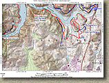 Here
is a PDF map of the area formatted for printing 8.5" x 11" paper. Here
is a PDF map of the area formatted for printing 8.5" x 11" paper. Here is the National Geographics TOPO! that contains both the North and South sides of Lake Hodges trail data. Also here are a GPX and KML files. Note the KML file is a single route that combines both the north and side side trails. |
 |
|
| Directions: From San Diego, take I-15 North towards Escondido, exit Pomarado Rd/West Rancho Bernardo Road. Take West Rancho Bernardo Road west. Travel for maybe 3/10ths of a mile until you see a dirt trail head parking lot on the right across from a retirement home. You can also go further up the road to the first stop light about 1/10th of a mile further and hang right. Parking in the parking lot by the tennis courts. | ||
| Ride information: (Points referred to in the description are shown on the map.) | ||
Note: This trail was burned in the 2007 Wildfires so some of the photo are a little dated. The area has recovered well and the flora continues to regrow. The description is based on if you are riding just riding on the south side but since the Bike and Pedestrain Bridge opened in May of 2009 the north and side of Lake Hodges connected. The 990 foot long, 12' wide Bridge is located 1000 feet west of I-15 bridge (Points R and O on my map). RIDE DESCRIPTION: From the dirt parking lot head northward along the concrete pathway alongside West Bernardo Drive. When get get down by the lake you will see a single track heading off the left (west) just before a fence and railing starts. Take this singletrack. |
||
|
||
|
||
| Shortly after the trail turns east, you will come to a split in the trail off to your right. You can take this right or the next right (they will both merge together) and turn south. After a short distance on either trail you will crose over the Green Valley creek bridge which is a 40 foot steel and wood bridge. | ||
|
||
 The top of the hill at Point M looking east at the area you came in from.This photo (and the one below) was taken when the lake was drained very low. It normal water level is much higher. |
||
|
||
Looking Northwest from the low lying singletrack between Point M and N. The large hill is on the right-hand side with Bernardo Mountain on the north side of the lake in the distance on the right hand side. |
||
|
||
  Around Point N you will cross over a creek and into a rather
large clearing/open area. From here just follow the trail back towards the lake
(North). Once the trail gets near the high water mark of the lake it bends
to the west and follows along its edge. Shortly after this point a singletrack bears off to to the right and goes up a small hill. Take this singletrack. It is a nice short climb with a little bit of technical after going over the top before it rejoins the main trail you were orginally on. Around Point N you will cross over a creek and into a rather
large clearing/open area. From here just follow the trail back towards the lake
(North). Once the trail gets near the high water mark of the lake it bends
to the west and follows along its edge. Shortly after this point a singletrack bears off to to the right and goes up a small hill. Take this singletrack. It is a nice short climb with a little bit of technical after going over the top before it rejoins the main trail you were orginally on. |
||
  At the junction of the main trail, bear to the right where the trail quickly turns into the respectable singletrack category. As you work you way
along this trail you will go through some scrub brush, stands of trees and open
meadow grasses. A nice bit of trail. Follow this singletrack in the northwestern direction as it parallels the shoreline towards Point O. At the junction of the main trail, bear to the right where the trail quickly turns into the respectable singletrack category. As you work you way
along this trail you will go through some scrub brush, stands of trees and open
meadow grasses. A nice bit of trail. Follow this singletrack in the northwestern direction as it parallels the shoreline towards Point O. |
||
|
||
     |
||
| A few pictures from along the route out to Point O | ||
  At Point O, turn around and retrace your steps back to the sidehill single track but this time stay on the main trail back to Point N. Retrace your path back to the steel/wood bridge. Cross the bridge and when you come out into the large open area bear to your right on a fireroad up to the main junction of trails to the southeast of the large hill at Point T. At Point O, turn around and retrace your steps back to the sidehill single track but this time stay on the main trail back to Point N. Retrace your path back to the steel/wood bridge. Cross the bridge and when you come out into the large open area bear to your right on a fireroad up to the main junction of trails to the southeast of the large hill at Point T. |
||
|
||
|
||
| To get in some more of the Benardo Bay trail (highly recommended) bear slightly left at Point T and to go north on the east side of the large hill. After going over a small saddle you will drop back down to the lake where you will connect to the singletrack you came in on. Hang a right to get back on the Benardo Bay trail and proceed towards Point P and back towards West Bernardo Drive. The singletrack will come out on a concrete pathway will you will hang a right and go back up to the the trailhead.. | ||
|
||
| The south side of Lake Hodges is an interesting ride all on its on own but using the bridge allows you to combine the best singletracks on the south side with the longer miles of the north side and the climbing workout of Bernardo Mountain. On the Lake Hodges - North Side I have a description of 29-mile route that combining both sides. | ||