
The Joplin Trail
  Joplin
is a technical trail lovers kind of trail located at the top of the Santa Ana
Mountains. It starts at the saddle of Modjeska and Santiago Peaks and
drops down the west slope of the mountains to an area called Old Camp.
Drops is a good word to describe this trail as it sheds off nearly 2,000 feet of
elevation in about 2 miles. The trail is often loose and rocky with some
chunky stuff here and there. Combined with an average grade of 20 percent
this is one of those places where you need to bring your "A" game to fully
appreciate this trail. You just can't drive to either the bottom or the
top of the trail so it requires some work to access it. The route
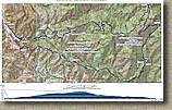
described here is a combination of the Harding Truck Trail,
Main Divide, Joplin, and the Santiago Truck Trail. It is a little over 25
miles long with just over 5,000 feet of climbing. Joplin alone
would be considered an advanced level trail, but combined with the cardio effort
required to get to the trail, I feel confident in calling this loop an advanced ride.
While Joplin can be ridden on any type of bike (skill level dependant of course)
I think most people would find the price of admission to lug a bigger
travel "All-Mountain" style bike up the mountain worth it. Joplin
is a technical trail lovers kind of trail located at the top of the Santa Ana
Mountains. It starts at the saddle of Modjeska and Santiago Peaks and
drops down the west slope of the mountains to an area called Old Camp.
Drops is a good word to describe this trail as it sheds off nearly 2,000 feet of
elevation in about 2 miles. The trail is often loose and rocky with some
chunky stuff here and there. Combined with an average grade of 20 percent
this is one of those places where you need to bring your "A" game to fully
appreciate this trail. You just can't drive to either the bottom or the
top of the trail so it requires some work to access it. The route
described here is a combination of the Harding Truck Trail,
Main Divide, Joplin, and the Santiago Truck Trail. It is a little over 25
miles long with just over 5,000 feet of climbing. Joplin alone
would be considered an advanced level trail, but combined with the cardio effort
required to get to the trail, I feel confident in calling this loop an advanced ride.
While Joplin can be ridden on any type of bike (skill level dependant of course)
I think most people would find the price of admission to lug a bigger
travel "All-Mountain" style bike up the mountain worth it. |
|
|
HAZARDS: In addition to the standard mountain biking hazards on
technical trails, if you are sensitive to poison oak, make sure you take
precautions such as leg warmers, sleeves, or the various blocking creams that
are on the market as well as a good after ride scrub. While not impending
out into the trail, the evil leaf is often close by just waiting for you to veer
off the line.
Directions: Take El Toro road exit off I5. Go east until it turns into Santiago Cyn Rd. Take S18 to Modjeska Canyon Road. Park in the large dirt area directly across from the turn off for Modjeska Canyon Road. |
Ride Notes: (This area was burned in the 2007 Wildfires. It is recovering well but your foliage my vary from the pictures here) |
|
|
|
|
Photo Note: All of the pictures of the ugly guy in the long sleeve blue jersey were taken by Jerry Daniels.
|
|
Before long Joplin drops out the scrub and sage into groves of
oak trees where the chunks get bigger. |
There are a few small incidental climbs along the descent but
nothing you would want to raise your seat for. You don't see ferns like this everyday in SoCal. Down near the bottom of Joplin there are some tricky
switchbacks. More pictures from Joplin
While Joplin is only two miles long, it is one of the few downhills I have done that feels longer than it actually is. Joplin rolls right out into a pretty cool looking wooded area called Old Camp. You should have gone about 16 miles total at this point. Old camp has a few spots to sit down and relax while enjoying a snack or two. Old Camp   |
Right as you come out of Old Camp you come to a T-intersection with a single track. Turn left and follow it uphill. I found the .4 mile climb up to the open spot at the top of the Upper Santiago Truck Trail to be a wee bit painful after the days earlier climbing efforts. As you come into the open area you will want to go directly across the open area to the downhill trail. The trail for the next four miles is a Grade-A blazefest with pretty good sight lines and slightly bermed turns. There are a couple of incidental climbs along this section but with all the downhill fun you will be having you will not care. After four miles of descending you will come to the junction of the Luge Trail on your left by a flag pole. At this point you are off of the Upper portion of the Santiago Truck Trail. (Technically the entire descent thus far has been on the Santiago Truck Trail, but so many people climb Santiago and then go down the Luge, that everything above the Luge is colloquially know as the Upper Santiago Truck Trail). Continue on past the Luge and start climbing for the next 1/2 mile. This climb can be a bummer since you have already put in 20 miles and plenty of climbing at this point. After this climb, the downhill fun resumes with only a few short ups to keep you honest. At about 23.6 miles the Santiago Truck Trail ends on Modjeska Grade road. Turn right and go downhill. The next .8 miles is pretty fun for pavement as it is steep and curvy. I have fundamental issues with descending pavement on a mountainbike, it just seems wrong. Anyway at the bottom of the hill bear left onto Modjeska Canyon road and coast or casually spin your way back to the parking area. Have whatever you want for dinner tonight because you most likely can't eat more calories in one meal than you burned today. |